PeakVisor will make you an expert in mountain navigation, providing you with advanced 3D maps, a high-quality route database, mountain identification features, and outdoor GPS track recording. Our app can meet all your mountain adventure needs in one stop: hiking, skiing, mountaineering, mountain biking, and more. But PeakVisor is more than just an outdoor app; it also presents you with an immersive 3D world, allowing you to have a thorough understanding of the subtleties of mountain terrain.
"PeakVisor uses your iPhone camera and augmented reality (AR) technology to show you the names and elevations of nearby mountains. This information will magically appear on your phone."
——Selected for the App Store feature "The Path Less Traveled"
Briefly introduce the tools we have prepared for you to help you understand and master mountains:
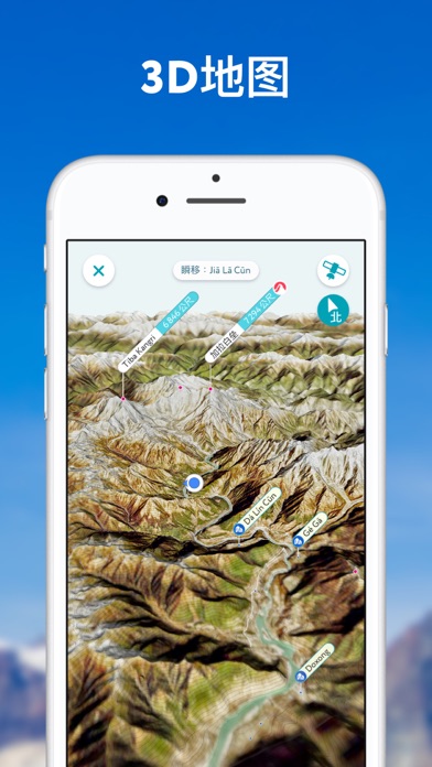
1. 3D Maps
● As humans achieve further success in sports related to mountains, the technology that can assist exploration is also advancing. With PeakVisor, you will unlock topographic maps beyond your time; our advanced technology, combined with high-precision terrain modeling, will take you deep into the mountain landscape you have selected. With just one glance, your understanding of the terrain of an area can catch up with what others have learned over the years. In addition, even if it is not as beautiful as real mountains and rivers, the visual effects presented by our 3D maps are enough for us to be proud.
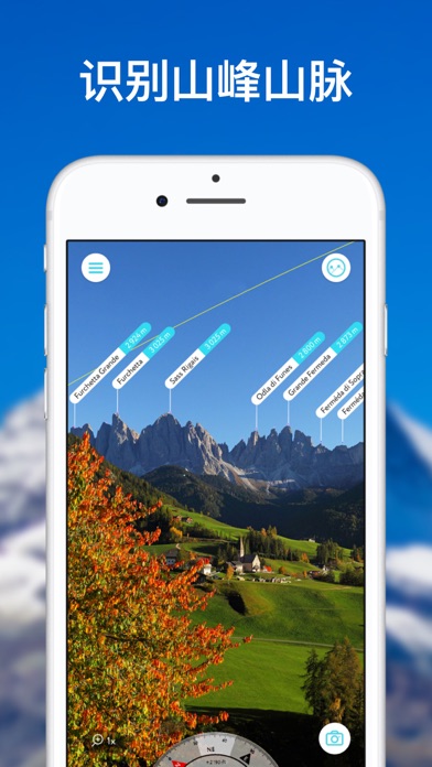
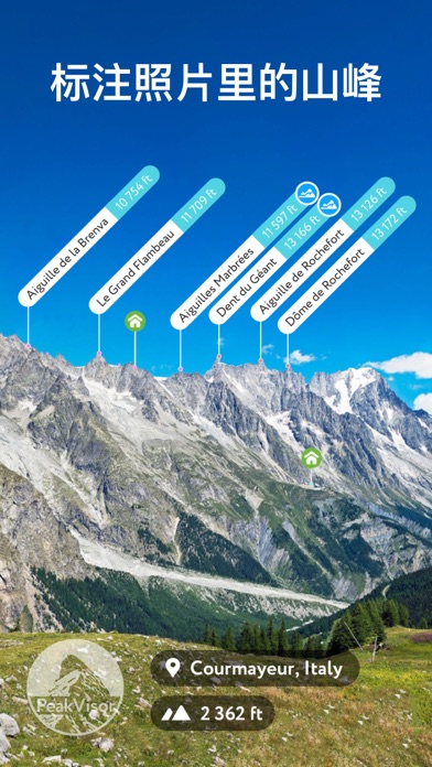
2. Identify Surrounding Mountains
● Identify more than a million peaks, ridges, crags, and ranges around the world and obtain detailed information about them! Our app will show you the elevation, topographic prominence, the mountain range it belongs to, national parks or protected areas, as well as photos and Wikipedia articles. Imagine standing in a strange place and being able to talk about mountain names and various information like a local.
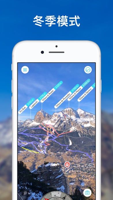
3. Winter Skiing
● In terms of winter mountain sports, through PeakVisor's 3D terrain map, you can visually understand the terrain and obtain detailed information about chairlifts, ski resort routes, and cross-country skiing travel routes. This app also provides features such as winter mode and slope layers to identify terrain where avalanches may occur on the route.
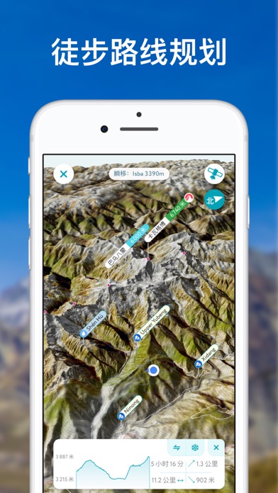
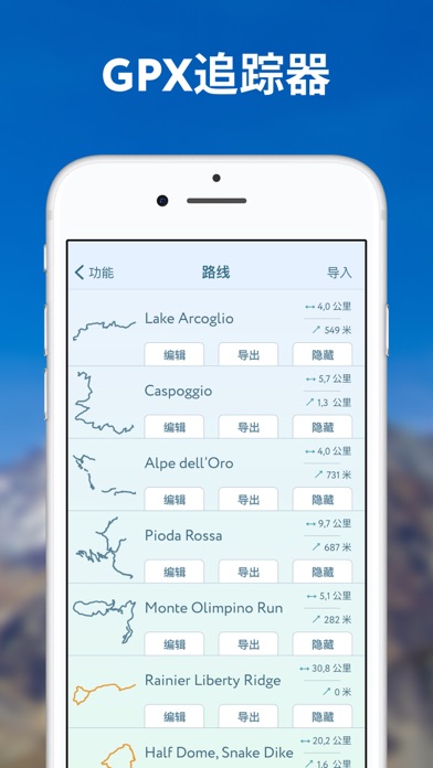
4. Route Planning
● We have been working hard to create a user-friendly app to help you complete an adventure plan from start to finish, covering aspects such as mountains, routes, summits, passes, viewpoints, and even parking areas. PeakVisor's 3D maps are covered with a vast global network of hiking and skiing routes, which can provide you with route visualization and key detail information, including distance, elevation profile, and estimated completion time. If the route you want is not on our map, you can also import and export GPX files through the app.
● Chairlifts and mountain huts are dotted on the 3D map and come with timetables. This is especially useful in Europe, where many mountain tops require taking a chairlift, helping you reduce a part of the extremely painful elevation climb. Moreover, only when you have enjoyed an unforgettable dinner and spent an unforgettable night in a simple mountain hut at a high altitude can you truly experience classical mountain culture.
● With lock screen navigation, you can continue to follow the track just by looking at your phone - no need to enter a password.
5. Share Your Adventure Journey Using GPS Tracking
● Track all outdoor activities, including hiking, skiing, mountain biking, etc. After the activity, you can visualize your track route in the miniature 3D world, view statistics such as distance and elevation gain, and export the GPX file of your new route.
● There are also monthly mountain challenges (such as vertical climb height, travel distance, etc.) and summit competitions in PeakVisor to keep mountain enthusiasts "continuously upward" motivated.
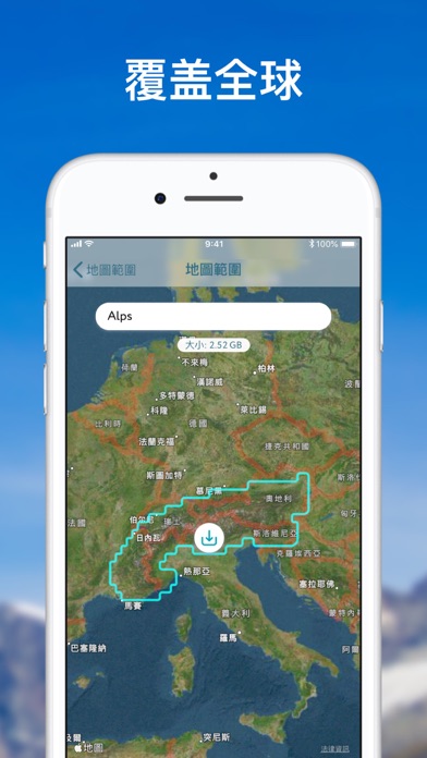
6. All Functions Support Offline Use
● All our 3D maps and layers support downloading, making it convenient to use in adventure environments without network.
7. Identify Mountains in Photos
● If you have photos of mountains taken with other apps before, you can also import the photos into PeakVisor to identify the mountains in the photos.
8. Aerial Animation Video
● You can even activate the "aerial view" function to generate a schematic video based on your route through eye-catching animations, so as to show it to your relatives and friends or arouse some memories at a certain moment in the future.
9. Mountain Widgets
● Who wouldn't like to use widgets, especially when this

 +100宝石

 分享
分享


用户评价
立即分享产品体验
你的真实体验,为其他用户提供宝贵参考
💎 分享获得宝石
【分享体验 · 获得宝石 · 增加抽奖机会】
将你的产品体验分享给更多人,获得更多宝石奖励!
💎 宝石奖励
每当有用户点击你分享的体验链接并点赞"对我有用",你将获得:
🔗 如何分享
复制下方专属链接,分享到社交媒体、群聊或好友:
💡 小贴士
分享时可以添加你的个人推荐语,让更多人了解这款产品的优点!
示例分享文案:
"推荐一款我最近体验过的应用,界面设计很精美,功能也很实用。有兴趣的朋友可以看看我的详细体验评价~"
领取结果