我的足迹: GPS 记录器
Essential for cycling, hiking, jogging, and mountain climbing
获取产品
 分享
分享

我的足迹: GPS 记录器
Essential for cycling, hiking, jogging, and mounta...
An APP that can record where you've been and your walking tracks is the best choice. It can save the places you've visited and set your own landmarks, which is very useful when climbing mountains.
推荐指数
﹣
0人评分
我的足迹: GPS 记录器
Essential for cycling, hiking,...

0

获取
ios
工具
导航
APP
导航
工具
EDITOR’S CHOICE
编辑推荐An APP that can record where you've been and your walking tracks is the best choice. It can save the places you've visited and set your own landmarks, which is very useful when climbing mountains.
DESCRIPTION
官方介绍
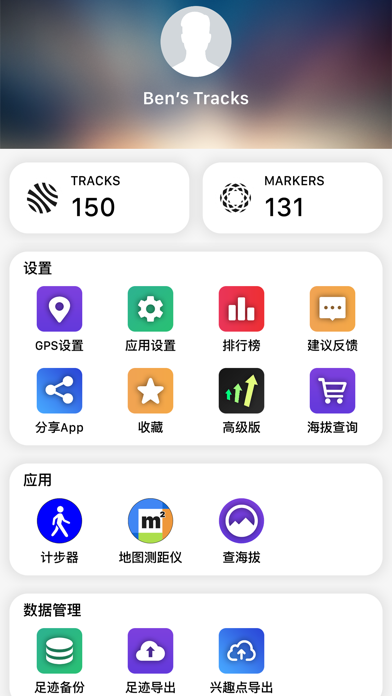
MyTracks is an application that records your location by using GPS data. It is very suitable for various activities such as hiking, jogging, walking, cycling, etc. This application uses advanced technology to provide accurate measurements and calculations.
Here are the things you can do with MyTracks:
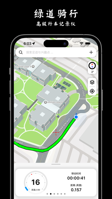
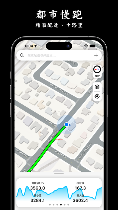
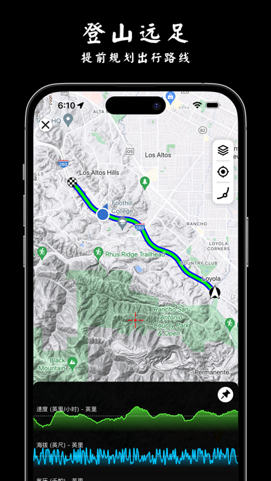
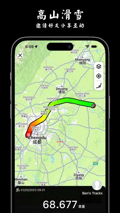
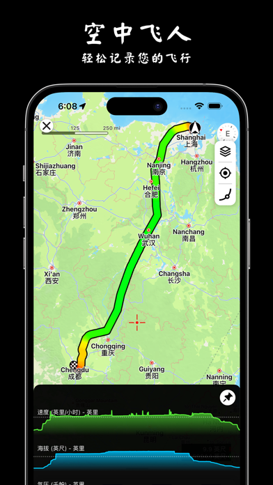
Record your route: Whether you are hiking, jogging or cycling, MyTracks can record your path and display it on the map.
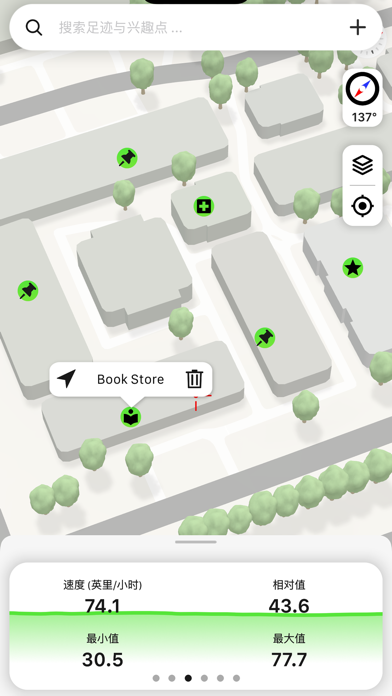
Save favorite locations: If there are specific locations you want to remember, you can mark them as favorites in the application.
Import and export data: MyTracks allows you to import and export data in various formats, such as CSV, GPX, KML and KMZ.
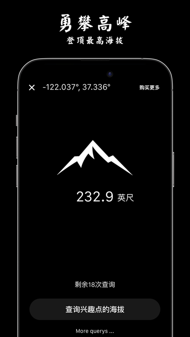
Improve accuracy: You can perform static GPS observations to obtain more accurate waypoints.
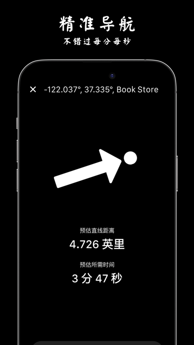
Navigate easily: The application provides waypoint guidance on the compass, allowing you to easily navigate to a specific location.
Customizable waypoints: You can add waypoints manually or import them from your favorite locations. You can even add vectors with angles and distances.
Coordinate conversion: MyTracks allows you to convert between four different coordinate formats (decimal, degrees minutes seconds, MGRS, UTM) at any time.
Other features: The application displays the glide ratio during recording, provides compass options in degrees or millidegrees, supports MGRS grid overlays on the map, and allows you to create a route before starting to track.
Detailed recording: You can view your track on the map and replay the route. The application provides detailed statistics about your track and displays the saved waypoints associated with each track. You can also change the color of the track for easier identification.
Please note that continuously using GPS in the background will quickly drain the device's battery. If you like our application, please share it with your friends to give us support! If you have any suggestions, you can also contact us at 7saiwen@gmail.com
Here are the things you can do with MyTracks:
Record your route: Whether you are hiking, jogging or cycling, MyTracks can record your path and display it on the map.
Save favorite locations: If there are specific locations you want to remember, you can mark them as favorites in the application.
Import and export data: MyTracks allows you to import and export data in various formats, such as CSV, GPX, KML and KMZ.
Improve accuracy: You can perform static GPS observations to obtain more accurate waypoints.
Navigate easily: The application provides waypoint guidance on the compass, allowing you to easily navigate to a specific location.
Customizable waypoints: You can add waypoints manually or import them from your favorite locations. You can even add vectors with angles and distances.
Coordinate conversion: MyTracks allows you to convert between four different coordinate formats (decimal, degrees minutes seconds, MGRS, UTM) at any time.
Other features: The application displays the glide ratio during recording, provides compass options in degrees or millidegrees, supports MGRS grid overlays on the map, and allows you to create a route before starting to track.
Detailed recording: You can view your track on the map and replay the route. The application provides detailed statistics about your track and displays the saved waypoints associated with each track. You can also change the color of the track for easier identification.
Please note that continuously using GPS in the background will quickly drain the device's battery. If you like our application, please share it with your friends to give us support! If you have any suggestions, you can also contact us at 7saiwen@gmail.com
更多
用户评价
用户评论
暂无用户评价,马上成为第一个评价该产品的人吧~
MyTracks is an application that records your location by using GPS data. It is very suitable for various activities such as hiking, jogging, walking, cycling, etc. This application uses advanced technology to provide accurate measurements and calculations.
Here are the things you can do with MyTracks:
Record your route: Whether you are hiking, jogging or cycling, MyTracks can record your path and display it on the map.
Save favorite locations: If there are specific locations you want to remember, you can mark them as favorites in the application.
Import and export data: MyTracks allows you to import and export data in various formats, such as CSV, GPX, KML and KMZ.
Improve accuracy: You can perform static GPS observations to obtain more accurate waypoints.
Navigate easily: The application provides waypoint guidance on the compass, allowing you to easily navigate to a specific location.
Customizable waypoints: You can add waypoints manually or import them from your favorite locations. You can even add vectors with angles and distances.
Coordinate conversion: MyTracks allows you to convert between four different coordinate formats (decimal, degrees minutes seconds, MGRS, UTM) at any time.
Other features: The application displays the glide ratio during recording, provides compass options in degrees or millidegrees, supports MGRS grid overlays on the map, and allows you to create a route before starting to track.
Detailed recording: You can view your track on the map and replay the route. The application provides detailed statistics about your track and displays the saved waypoints associated with each track. You can also change the color of the track for easier identification.
Please note that continuously using GPS in the background will quickly drain the device's battery. If you like our application, please share it with your friends to give us support! If you have any suggestions, you can also contact us at 7saiwen@gmail.com
更多


DESCRIPTION
官方介绍
MyTracks is an application that records your location by using GPS data. It is very suitable for various activities such as hiking, jogging, walking, cycling, etc. This application uses advanced technology to provide accurate measurements and calculations.
Here are the things you can do with MyTracks:
Record your route: Whether you are hiking, jogging or cycling, MyTracks can record your path and display it on the map.
Save favorite locations: If there are specific locations you want to remember, you can mark them as favorites in the application.
Import and export data: MyTracks allows you to import and export data in various formats, such as CSV, GPX, KML and KMZ.
Improve accuracy: You can perform static GPS observations to obtain more accurate waypoints.
Navigate easily: The application provides waypoint guidance on the compass, allowing you to easily navigate to a specific location.
Customizable waypoints: You can add waypoints manually or import them from your favorite locations. You can even add vectors with angles and distances.
Coordinate conversion: MyTracks allows you to convert between four different coordinate formats (decimal, degrees minutes seconds, MGRS, UTM) at any time.
Other features: The application displays the glide ratio during recording, provides compass options in degrees or millidegrees, supports MGRS grid overlays on the map, and allows you to create a route before starting to track.
Detailed recording: You can view your track on the map and replay the route. The application provides detailed statistics about your track and displays the saved waypoints associated with each track. You can also change the color of the track for easier identification.
Please note that continuously using GPS in the background will quickly drain the device's battery. If you like our application, please share it with your friends to give us support! If you have any suggestions, you can also contact us at 7saiwen@gmail.com
Here are the things you can do with MyTracks:
Record your route: Whether you are hiking, jogging or cycling, MyTracks can record your path and display it on the map.
Save favorite locations: If there are specific locations you want to remember, you can mark them as favorites in the application.
Import and export data: MyTracks allows you to import and export data in various formats, such as CSV, GPX, KML and KMZ.
Improve accuracy: You can perform static GPS observations to obtain more accurate waypoints.
Navigate easily: The application provides waypoint guidance on the compass, allowing you to easily navigate to a specific location.
Customizable waypoints: You can add waypoints manually or import them from your favorite locations. You can even add vectors with angles and distances.
Coordinate conversion: MyTracks allows you to convert between four different coordinate formats (decimal, degrees minutes seconds, MGRS, UTM) at any time.
Other features: The application displays the glide ratio during recording, provides compass options in degrees or millidegrees, supports MGRS grid overlays on the map, and allows you to create a route before starting to track.
Detailed recording: You can view your track on the map and replay the route. The application provides detailed statistics about your track and displays the saved waypoints associated with each track. You can also change the color of the track for easier identification.
Please note that continuously using GPS in the background will quickly drain the device's battery. If you like our application, please share it with your friends to give us support! If you have any suggestions, you can also contact us at 7saiwen@gmail.com
更多
Made with ❤ by Mergeek


 App Store