


 App Store


加入 Mergeek 福利群
扫码添加小助手,精彩福利不错过!
若不方便扫码,请在 Mergeek 公众号,回复 群 即可加入
- 精品限免
- 早鸟优惠
- 众测送码
 Hiking Map Poland
Route planning
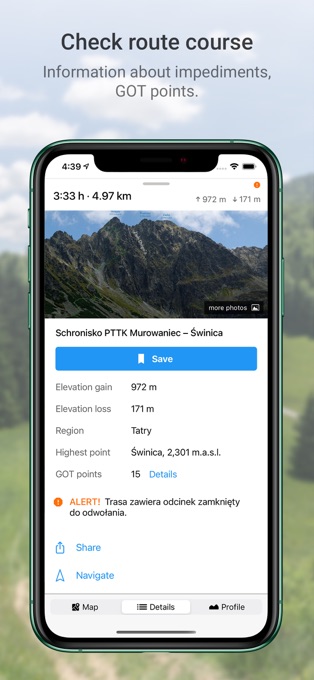
The main functionality is planning routes leading along official hiking trails in the mountains and foothills of Poland. The app finds a route quick and easy, displays it on a map, shows its length, estimated time, detailed course and elevation profile. It also shows your current location.
Routes are displayed on detailed Touristic map layer with contours and terrain shading, which contains peaks, passes, parkings and other points of interest. It's also possible to download maps of regions listed further in this description and use them offline.
Tracks recording
Second main functionality is recording tracks. You can then share it with your friends!
Interesting places
The app also displays information about points of interest: photos and opinions taken from the mapa-turystyczna.pl website.
Detailed functionalities:
- planning routes based on given points; points can be chosen from map or found using the search box,
- intelligent search suggestions, considering spots closest to your location and those most popular,
- displaying routes on a map along with their length, estimated time, route details (spots and trails) and elevation profile,
- information about impediments on route,
- GOT points for planned route,
- showing your current location on the map,
- compass,
- track recording, showing elapsing distance and time,
- list of recorded tracks,
- searching for places and showing them on the map,
- displaying information about places your searched for: photos and opinions taken from mapa-turystyczna.pl website,
- navigation on planned route,
- detailed touristic maps layer, also available for download.
Available trails from regions:
* Beskidy
** Beskid Makowski
** Beskid Mały
** Beskid Niski
** Beskid Sądecki
** Beskid Śląski
** Beskid Śląsko-Morawski
** Beskid Wyspowy
** Beskid Żywiecki
** Bieszczady
** Gorce
* Sudety (Sudeten)
** Góry Bardzkie
** Góry Bystrzyckie
** Góry Orlickie
** Góry Izerskie
** Góry Kaczawskie
** Góry Kamienne
** Góry Opawskie
** Góry Sowie
** Góry Stołowe (Table Mountains)
** Góry Wałbrzyskie
** Góry Złote
** Góry Bialskie
** Karkonosze
** Kotlina Jeleniogórska
** Masyw Śnieżnika
** Rudawy Janowickie
* Pogórze Sudeckie
** Pogórze Izerskie
** Pogórze Kaczawskie
* Przedgórze Sudeckie
** Masyw Ślęży
** Przedgórze Paczkowskie
** Równina Świdnicka
** Wzgórza Niemczańsko-Strzelińskie
** Wzgórza Strzegomskie
* Pogórze Beskidzkie
** Pogórze Ciężkowickie
** Pogórze Przemyskie
** Pogórze Rożnowskie
** Pogórze Strzyżowskie
** Pogórze Dynowskie
** Pogórze Wielickie
** Pogórze Wiśnickie
* Other
** Wolin Island
** Góry Świętokrzyskie
** Płaskowyż Suchedniowski
** Kampinos Forest
** Jura Krakowsko-Częstochowska
** Brama Krakowska (Cracow's surroundings)
** Pieniny
** Pogórza Przedtatrzańskie
** Działy Orawskie
** Tatry (Tatra Mountains)
* Slovakia
** Góry Choczańskie (Choč Mountains)
** Skoruszyńskie Wierchy
** Góry Kysuckie (Kysuce Highlands)
** Magura Orawska (Orava Magura)
** Magura Spiska (Spiš Magura)
** Mała Fatra (Lesser Fatra)
** Niżne Tatry (Low Tatra Mountains)
** Słowacki Raj (Slovak Paradise)
** Wielka Fatra (Great Fatra)
** Wysokie Tatry (High Tatra Mountains)
Planning routes and displaying information about places need internet connection.
Continued use of GPS running in the background can dramatically decrease battery life.
Terms of Use (EULA): https://mapa-turystyczna.pl/regulamin
Route planning
The main functionality is planning routes leading along official hiking trails in the mountains and foothills of Poland. The app finds a route quick and easy, displays it on a map, shows its length, estimated time, detailed course and elevation profile. It also shows your current location.
Routes are displayed on detailed Touristic map layer with contours and terrain shading, which contains peaks, passes, parkings and other points of interest. It's also possible to download maps of regions listed further in this description and use them offline.
Tracks recording
Second main functionality is recording tracks. You can then share it with your friends!
Interesting places
The app also displays information about points of interest: photos and opinions taken from the mapa-turystyczna.pl website.
Detailed functionalities:
- planning routes based on given points; points can be chosen from map or found using the search box,
- intelligent search suggestions, considering spots closest to your location and those most popular,
- displaying routes on a map along with their length, estimated time, route details (spots and trails) and elevation profile,
- information about impediments on route,
- GOT points for planned route,
- showing your current location on the map,
- compass,
- track recording, showing elapsing distance and time,
- list of recorded tracks,
- searching for places and showing them on the map,
- displaying information about places your searched for: photos and opinions taken from mapa-turystyczna.pl website,
- navigation on planned route,
- detailed touristic maps layer, also available for download.
Available trails from regions:
* Beskidy
** Beskid Makowski
** Beskid Mały
** Beskid Niski
** Beskid Sądecki
** Beskid Śląski
** Beskid Śląsko-Morawski
** Beskid Wyspowy
** Beskid Żywiecki
** Bieszczady
** Gorce
* Sudety (Sudeten)
** Góry Bardzkie
** Góry Bystrzyckie
** Góry Orlickie
** Góry Izerskie
** Góry Kaczawskie
** Góry Kamienne
** Góry Opawskie
** Góry Sowie
** Góry Stołowe (Table Mountains)
** Góry Wałbrzyskie
** Góry Złote
** Góry Bialskie
** Karkonosze
** Kotlina Jeleniogórska
** Masyw Śnieżnika
** Rudawy Janowickie
* Pogórze Sudeckie
** Pogórze Izerskie
** Pogórze Kaczawskie
* Przedgórze Sudeckie
** Masyw Ślęży
** Przedgórze Paczkowskie
** Równina Świdnicka
** Wzgórza Niemczańsko-Strzelińskie
** Wzgórza Strzegomskie
* Pogórze Beskidzkie
** Pogórze Ciężkowickie
** Pogórze Przemyskie
** Pogórze Rożnowskie
** Pogórze Strzyżowskie
** Pogórze Dynowskie
** Pogórze Wielickie
** Pogórze Wiśnickie
* Other
** Wolin Island
** Góry Świętokrzyskie
** Płaskowyż Suchedniowski
** Kampinos Forest
** Jura Krakowsko-Częstochowska
** Brama Krakowska (Cracow's surroundings)
** Pieniny
** Pogórza Przedtatrzańskie
** Działy Orawskie
** Tatry (Tatra Mountains)
* Slovakia
** Góry Choczańskie (Choč Mountains)
** Skoruszyńskie Wierchy
** Góry Kysuckie (Kysuce Highlands)
** Magura Orawska (Orava Magura)
** Magura Spiska (Spiš Magura)
** Mała Fatra (Lesser Fatra)
** Niżne Tatry (Low Tatra Mountains)
** Słowacki Raj (Slovak Paradise)
** Wielka Fatra (Great Fatra)
** Wysokie Tatry (High Tatra Mountains)
Planning routes and displaying information about places need internet connection.
Continued use of GPS running in the background can dramatically decrease battery life.
Terms of Use (EULA): https://mapa-turystyczna.pl/regulamin
第一时间掌握精选限免应用/游戏信息
自定义喜欢的应用/游戏的价格变动
了解内购应用/游戏的限免或降价活动
查看应用/游戏价格历史等待合适时机再出手
第一时间收到价格通知不错过省钱机会

扫码下载 Follow
 放松双眼
放松双眼
放松双眼是一款专为学生党、白领等重度用眼人群开发的护眼 APP,遵循国际眼科医生权威推荐的 20-2...

 酵母君
酵母君
这款多功能 APP 集成了电子书阅读、音乐播放、互动卡片、漫画阅读、3D 模型预览及个性相册六大核心...
 Bookord
欢迎使用 Bookord。Bookord 是一款专为热爱阅读的人士设计的应用程序,旨在帮助用户记录每...
 163
163


放松双眼是一款专为学生党、白领等重度用眼人群开发的护眼 APP,遵循国际眼科医生权威推荐的 20-2...
6

这款多功能 APP 集成了电子书阅读、音乐播放、互动卡片、漫画阅读、3D 模型预览及个性相册六大核心...
3


欢迎使用 Bookord。Bookord 是一款专为热爱阅读的人士设计的应用程序,旨在帮助用户记录每...
天天发现优质应用
 到主屏幕
到主屏幕


产品名
这项是必须填的哦~可用平台
产品链接
这项是必须填的哦~产品一句话介绍
这项是必须填的哦~开发者邮箱
你也可以发送更多的产品故事到 hi@mergeek.com
我们会让你的产品被更多用户看到!
产品名
这项是必须填的哦~可用平台
产品链接
这项是必须填的哦~产品一句话介绍
这项是必须填的哦~开发者邮箱
你也可以发送更多的产品故事到 hi@mergeek.com
我们会让你的产品被更多用户看到!
已经成功发送到你的邮箱了,请注意查收
关注公众号「 mergeek 」
下载链接推送到手机上
更方便获取APP
* 有的产品会有多个地址
你可以选择下载
你成为这个产品的发现者啦,说说你的推荐语吧!