


 +100宝石



产品功能
The topographic map of Europe that works where the signal doesn't.
Offline Topo Map puts the best free topo maps of Europe on your iPhone and iPad: the official national maps of Switzerland, France, Germany, Austria and South Tyrol, plus OpenTopoMap and TopPlusOpen for the rest of the continent, from the Pyrenees to Scandinavia. Pick a map, draw a rectangle over the area you are heading into, download it, and the map keeps working when your phone has no connection at all.
WHAT YOU GET
• Six topo maps, one tap apart — OpenTopoMap (worldwide), swisstopo (Switzerland), Plan IGN (France), TopPlusOpen (Germany and Europe), basemap.at (Austria) and South Tyrol. A single layers button switches between them; each national map shows where it covers, and a tap takes you there.
• Hillshade on any map — shaded relief drawn on your phone from open elevation data, so even a flat official map shows ridges and gullies at a glance.
• Slopes for ski touring — steepness above 30° on top of the map, from IGN, across the French mountains.
• Draw it, download it — tap the dashed rectangle, drag across the map, touch and hold to nudge it into place, then download zoom levels 0 to 17 in one go. The download stores the map you picked plus the overlays you have switched on.
• Know the size first — before anything is fetched you see the tile count and an estimated download size, so a careless swipe never turns into a gigabyte.
• Your GPX tracks, from any app — share a .gpx file from Files, Mail, Safari or any other app and it appears on the map. Rename a track, hide it without deleting it, or remove it.
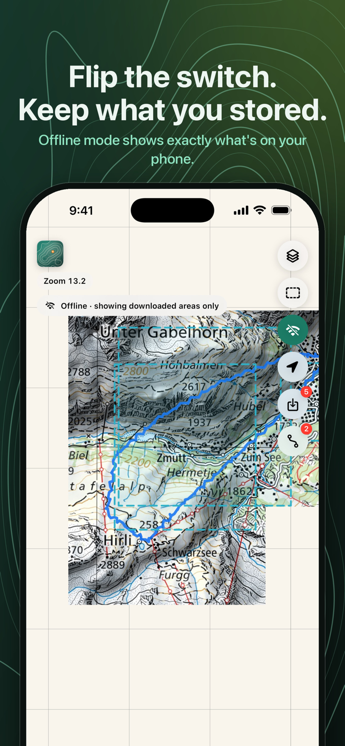
• The offline switch — flip it and the map shows only what you have stored, with every saved area outlined. What you see is exactly what you will have on the mountain.
• Downloads that finish — lock the phone or lose the connection and nothing is lost. Every area remembers what it is missing, and one tap fetches only the rest.
• Find yourself — one tap centres the map on your position. Location is used on the device only.
• Your storage, your rules — a downloads list shows each area with its map, size and date. Delete one, delete all, or jump straight to it on the map.
BUILT FOR THE OUTDOORS
Plan at home on a big screen, then find your way on an Alpine hut-to-hut trek, a ski tour in the Dolomites or a bikepacking trip through valleys with one bar of signal or none. No roaming data needed abroad: what you stored is on your phone. The app sends nothing but map tile requests, has no account, no ads and no tracking, and collects no personal data. GPX files stay on your device.
BUILT ON OPEN DATA
OpenTopoMap © OpenTopoMap (CC-BY-SA), map data © OpenStreetMap contributors, SRTM. swisstopo © swisstopo. Plan IGN and slopes © IGN, Licence Ouverte Etalab 2.0. TopPlusOpen © BKG, dl-de/by-2-0. basemap.at, CC BY 4.0. South Tyrol © Autonome Provinz Bozen – Südtirol, CC0. Relief from AWS Terrain Tiles, EU-DEM © Copernicus, SRTM/USGS. Offline Topo Map is an independent client and is not affiliated with any of these providers. To keep their services healthy, each download is capped at 15,000 tiles and the app backs off whenever a server asks it to.
A NOTE ON SAFETY
Map data can be incomplete or outdated. Use the map as an aid alongside an official paper map and your own judgement, never as your only means of navigation in terrain where getting lost is dangerous.
Questions or ideas? Visit offlinetopomap.com.
分享「」体验,参与「」抽奖!
分享 1~3 张你对这个产品最满意的截图或效果图
分享「」体验,参与「」抽奖!
用你的故事点亮社区✨!你的真实体验,将会永久展示在 官方主页 📌,为其他朋友提供宝贵参考 💡。立即分享吧!🚀
请为产品评分
请选择问题回答,为大家提供宝贵参考
选择要回答的问题
温馨提示
你尚未上传产品截图。
上传截图可立即获得宝石积分奖励!
如果你赶时间,也可稍后修改评论,补上截图领取宝石。
温馨提醒
你尚未添加产品截图
⚠️ 不添加截图将降低抽奖权重

感谢参加,你已成功参加!
为了确保你能及时收到审核结果和领奖码通知

扫描二维码关注 Mergeek 公众号
在后台回复 「获奖通知」
完成上述操作,即可保障奖励发放成功





用户评价
立即分享产品体验
你的真实体验,为其他用户提供宝贵参考
💎 分享获得宝石
【分享体验 · 获得宝石 · 增加抽奖机会】
将你的产品体验分享给更多人,获得更多宝石奖励!
💎 宝石奖励
每当有用户点击你分享的体验链接并点赞"对我有用",你将获得:
🔗 如何分享
复制下方专属链接,分享到社交媒体、群聊或好友:
💡 小贴士
分享时可以添加你的个人推荐语,让更多人了解这款产品的优点!
示例分享文案:
"推荐一款我最近体验过的应用,界面设计很精美,功能也很实用。有兴趣的朋友可以看看我的详细体验评价~"
关注 Mergeek 公众号
领奖遇到问题?联系小门助手